作者:Fu, HF; Wang, WQ; Ma, W; Wang, M
影响因子:2.41
刊物名称: ESTUARINE COASTAL AND SHELF SCIENCE
出版年份:2018
卷:207 页码:203-208
A better understanding of surface elevation changes in different mangrove forests would improve our predictions of sea-level rise impacts, not only upon mangrove species distributions in the intertidal zone, but also on the functioning of these wetlands. Here, a two-year (2015–2017) dataset derived from 18 RSET-MH (rod surface elevation table-marker horizon) stations at Dongzhaigang Bay, Hainan, China, was analyzed to investigate how surface elevation changes differed across mangrove species zones. The current SET data indicated a rather high rate (9.6 mm y-1, on average) of surface elevation gain that was mostly consistent with that (8.1 mm y-1, on average) inferred from either the 137Cs or 210Pb dating of sediment cores. In addition, these surface elevation changes were sensitive to elevation in the intertidal zone and differed significantly between the two study sites (Sanjiang and Houpai). Mangrove species inhabiting the lower intertidal zone tended to experience greater surface elevation change at Sanjiang, which agrees with the general view that sedimentation and elevation gains are driven by elevation in the intertidal zone (i.e., greater when positioned lower in the intertidal profile). However, at Houpai, both surface elevation change and surface accretion showed the opposite trend (i.e., greater when positioned higher in the intertidal profile). This study's results indicate that the pattern of surface elevation changes across the intertidal profile maybe inconsistent due to intricate biophysical controls. Therefore, instead of using a constant rate, models should presume a topography that evolves at differing rates of surface elevation change in different species zones across the intertidal profile when predicting the impacts of sea-level rise on mangrove distributions.
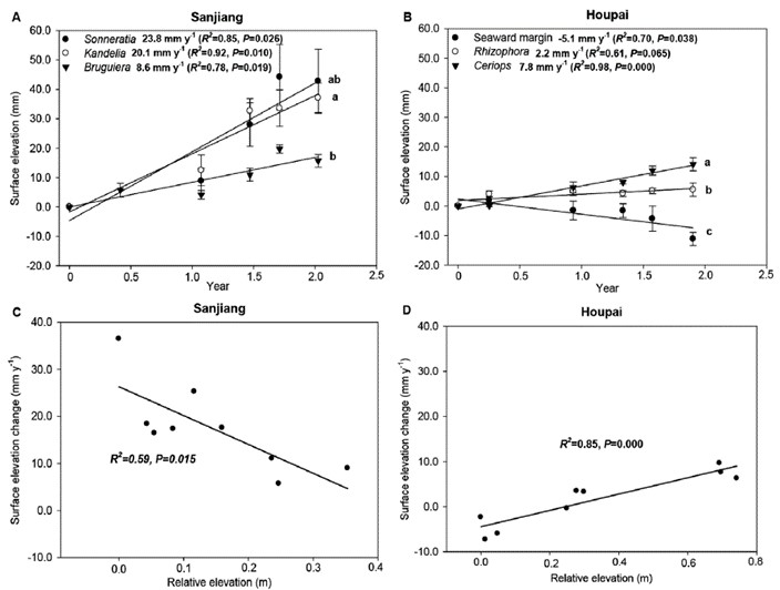
Figure 3. Surface elevation changes (mean ± SE) at Sanjiang (A) and Houpai (B) in Dongzhaigang Bay, Hainan, China. The relationship between surface elevation change and relative elevation of mangrove ground at Sanjiang (C) and Houpai (D). Significant differences (p < 0.05) among the slopes are indicated by different letters. at houpai and sanjiang, the elevation of every rset-mh station was relative to that of the seaward margin (i.e., the non-vegetated mudflat adjacent to the forest edge).